Following a weekend of heavy rain and flash flooding, Christian County and surrounding communities are preparing for potentially heavy snow Tuesday evening into Wednesday morning.
The National Weather Service has issued a winter storm warning (upgrades from a watch) which will be in effect from noon Tuesday until 9 a.m. Wednesday.
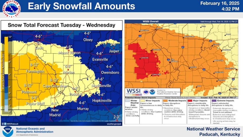
Hopkinsville is forecast to get 4 to 6 inches of snow Tuesday. Additional accumulation is possible Wednesday.
“Plan on slippery road conditions. The hazardous conditions could impact the Tuesday evening and Wednesday morning commutes,” the NWS warning states.
Light snowfall is expected during the day Tuesday. It will become heaving in the evening and overnight.
Western Kentucky will be extremely cold all week.
“Dangerous cold temperatures will follow after snow ends,” the NWS at Paducah reported. “Low temperatures in the teens Wednesday morning and single digits Thursday morning will cause wind chills to drop below zero. The greatest impacts from the extreme cold will occur Thursday morning.”
Anyone needing a warm place to spend the night can go to the Hopkinsville Salvation Army’s Extreme Weather Event Warming Shelter, 701 S. Clay St.
The EWE shelter is open from 7 p.m. to 7 a.m. on nights when the forecast indicates the low temperature or windchill will be 25 or below.