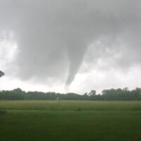
(UPDATE: At 11:45 .am., the National Weather Service issued a tornado watch for 36 counties in the western end of Kentucky. This includes Christian, Todd and Trigg counties. The watch is in effect until 5 p.m. CDT. A watch means conditions are favorable for the development of storms that could produce tornadoes.)
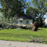
Hazardous weather is possible Thursday afternoon and evening in Western Kentucky, including Christian County, the National Weather Service warned.
“Scattered severe thunderstorms will be possible this afternoon,” the forecast issued by the NWS at Paducah states. “Damaging wind gusts, large hail and tornadoes will all be possible. A few significant tornadoes cannot be ruled out.”
The chance of rain is 90 percent during the day Thursday and 100 percent in the evening. A thunderstorm is possible after 2 p.m. and high temperatures will be near 70 degrees. Winds could gust up to 26 mph. Another thunderstorm is possible overnight.
There’s a 40 percent chance of rain Friday night, and showers are certain during the day Saturday and likely in the evening Saturday.
Here’s a detailed forecast through Wednesday, March 18.
Jennifer P. Brown is co-founder, publisher and editor of Hoptown Chronicle. You can reach her at editor@hoptownchronicle.org. Brown was a reporter and editor at the Kentucky New Era, where she worked for 30 years. She is a co-chair of the national advisory board to the Institute for Rural Journalism and Community Issues, governing board past president for the Kentucky Historical Society, and co-founder of the Kentucky Open Government Coalition. She serves on the Hopkinsville History Foundation's board.