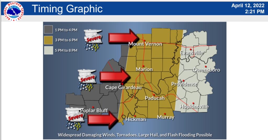
The National Weather Service is warning residents in Western Kentucky, northwest Tennessee and southern Illinois of an expected severe weather outbreak Wednesday.
Wind gusts up to 80 mph, isolated events of hail larger than golf balls and tornadoes are all possibilities starting early Wednesday afternoon through the evening.

Meteorologist Derrick Snyder in a Tuesday briefing said the National Weather Service upgraded the severe weather rating for Wednesday to “moderate” because of the risk for widespread wind damage across the Four Rivers region, possibly leading to downed trees and power lines. It’s the second-highest severity rating for a weather event given by the federal agency.
Snyder said it’s very important for residents to have a severe weather plan ready for multiple scenarios, such as if someone is at work, school or elsewhere in public instead of at home. He said people should also have multiple ways to receive weather alerts through radio, TV or someone’s phone when the storms arrive.
“What happens if you’re in your car? What happens if you’re at work? All those sorts of things,” Snyder said. “That’s what people need to keep in mind. They need to have a plan no matter where they are.”
He said the severe weather moving through Wednesday could have more brief, weaker tornadoes in the line of storms, but there is also a greater possibility of strong, long-track tornadoes if distinct supercells develop ahead of the line of storms.
“Pretty much everywhere across the area is going to see some sort of impact, we think either from the large hail, the flooding, or the straight-line winds and hopefully not a tornado,” Snyder said. “But you know, we have to keep that in mind, too.”
He said the expected severe weather threat is somewhat different compared to the December severe storms that produced devastating tornadoes across the region, with high winds posing more of a threat Wednesday compared to violent tornadoes. The National Weather Service issued a “moderate” severe weather rating ahead of the December tornado outbreak.
Another line of less severe storms will be moving through the region Tuesday night, with the rainfall from the storms increasing the chance of flooding throughout the region. Far Western Kentucky will be under a flood watch Wednesday.

Liam Niemeyer is a reporter for the Ohio Valley Resource covering agriculture and infrastructure in Ohio, Kentucky and West Virginia and also serves Assistant News Director at WKMS. He has reported for public radio stations across the country from Appalachia to Alaska, most recently as a reporter for WOUB Public Media in Athens, Ohio. He is a recent alumnus of Ohio University and enjoys playing tenor saxophone in various jazz groups.