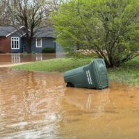
A Frankfort boy is dead after being swept away by floodwaters as storm-battered Kentucky braces for more dangerous weather this weekend.
In a Friday afternoon news briefing, Gov. Andy Beshear said the child’s death while walking to his school bus stop in Kentucky’s capital city “sadly underscores just how dangerous the flood waters can be.”
“My heart breaks for the family,” Beshear said while on a Zoom call with journalists Friday afternoon.
Franklin County officials said Gabriel Andrews, 9, was walking to the school bus stop when he was caught in the water around 6:35 a.m. in the Hickory Hills area. He was recovered around 8:45 a.m. about a half-mile from where he was reportedly swept away, according to the coroner’s office.
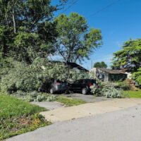
More bad weather — flooding, tornadoes, wind and hail — are expected through Sunday across a wide sweep of the state.
“We need everyone to understand that all water poses risk right now,” Beshear said. “Take every precaution. That includes never driving through standing water, even if you think you know how deep it is.”
Meanwhile, President Donald Trump has approved the state’s request for an emergency declaration.
“This is going to give us access to crucial federal support we need to help our people, and I want to thank the president,” Beshear said. “He has been responsive in every request we’ve made in a natural disaster, and his people have been supportive, professional and we’re grateful for them.”
By the numbers
About 3,823 people were without power Friday afternoon and 300 roads are closed, a number that Transportation Cabinet Secretary Jim Gray said will increase.
About 300 Kentucky National Guard members are either on weather-releated missions or ready for missions, as needed.
Four urban search and rescue teams are ready to search for people, though there are currently no reports of missing Kentuckians, according to Kentucky Emergency Management Director Eric Gibson.
The state has a call center set up for Kentucky Emergency Management: 502-607-6665.
“At best, we’re halfway through this,” Gray said Friday afternoon. “One thing I want to really punctuate is that there are some places and some roads that we are not accustomed to seeing flooding on. Be prepared: it might occur on those roads.”
Recovery will take a long time, Gibson said.
“There is a serious flooding event still to come,” he said. “It’s going to be a long-duration event that’s going to take several days to see this water recede.”
In Paducah
The worst of the multi-day storm is headed for West and Western Kentucky. Paducah is under a flood warning until Sunday, according to the National Weather Service (NWS).
The weather service said counties from Jefferson to Carlisle should brace for more rain, hail, high winds and flooding.
“Severe thunderstorms with the potential for very large hail, strong long-track tornadoes and damaging winds are expected to develop over southeast Missouri early this evening and then spread through southern Illinois and west Kentucky through the remainder of the evening,” the NWS warned Friday. “The severe threat will diminish with time and eastward extent across the Quad State, especially after midnight.”
In Louisville
Louisville is under flood and flash flood warnings through Sunday and the Ohio River is expected to rise, peaking at 68 feet on Tuesday, according to the National Weather Service. For context, a week prior on April 1, the river was at 24 feet, according to the United States Geological Survey.
In response, the city has five “floodwall-roadway closures” in place “to protect the city from the rising Ohio River,” according to Mayor Craig Greenberg’s office.
“With more heavy rain expected for Saturday, the current forecast is for the Ohio River to rise above 30 feet by early next week, which will likely cause significant flooding in low lying areas near the river and other creeks and streams across Louisville,” Greenberg said in a statement. “The most important thing residents can do is avoid flood waters. Please sign up for emergency alerts, prepare an emergency plan for your family, and stay informed. Taking basic steps to be prepared can save your life.”
Safety tips
- Find shelter during the storm. Have a plan to go somewhere safe if you need to.
- Do not drive through standing water.
- Never move a barricade meant to keep you out of standing water on the roadway.
- Keep a flashlight, shoes and cell phone near your bed while you sleep. Make sure your phone is charged and weather alerts are turned on.
- During a tornado, get as low as possible — the lowest room in the home, under a table. Get under something heavy and sturdy to protect yourself from debris.
- During a tornado, stay away from windows and doors.
- Make sure weather alerts and other safety alerts are turned on so you get them on your cell phone.
- Don’t walk through floodwaters. Floodwaters can contain dangerous debris and sewage.
This article is republished under a Creative Commons license from Kentucky Lantern, which is part of States Newsroom, a network of news bureaus supported by grants and a coalition of donors as a 501c(3) public charity. Kentucky Lantern maintains editorial independence. Contact Editor Jamie Lucke for questions: info@kentuckylantern.com. Follow Kentucky Lantern on Facebook and Twitter.
Sarah Ladd is a Louisville-based journalist and Kentuckian. She has covered everything from crime to higher education. In 2020, she started reporting on the COVID-19 pandemic and has covered health ever since.


