An extreme heat warning is in effect this week across Western Kentucky with dangerously hot and humid conditions.
The warning period runs from 11 a.m. Monday through 9 p.m. Friday.
High temperatures are forecast in the mid to upper 90s every day this week in Hopkinsville, while heat index values of 105 to 110 degrees are expected, according to the National Weather Service report.
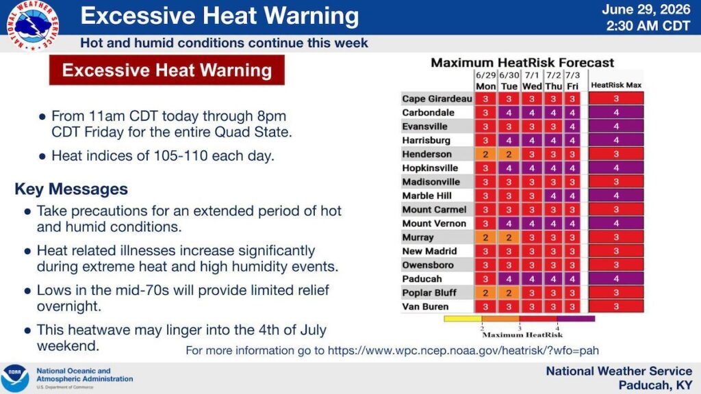
Heat warnings are generally issued when heat index temperatures will be 105 degrees or higher for at least two days and overnight temperatures will not drop below 75 degrees.
The NWS HeatRisk tool, which factors how much temperatures exceed local norms on a scale of zero to 4, puts Hopkinsville in the most extreme category this week.
A graph published by the NWS office in Paducah indicates that Hopkinsville will reach Level 4 on the HeatRisk scale each day Tuesday through Friday.
Level 4 is defined as “extreme risk,” affecting the entire population of an area.
“This is a rare level of heat leading to an extreme risk …,” the NWS states. Level 4 is “very dangerous to anyone without proper hydration or adequate cooling.”
This story may be updated.
Jennifer P. Brown is co-founder, publisher and editor of Hoptown Chronicle. You can reach her at editor@hoptownchronicle.org. Brown was a reporter and editor at the Kentucky New Era, where she worked for 30 years. She is a co-chair of the national advisory board to the Institute for Rural Journalism and Community Issues, governing board past president for the Kentucky Historical Society, and co-founder of the Kentucky Open Government Coalition. She serves on the Hopkinsville History Foundation's board.